

When field and office workflows outgrow the tools supporting them.
A managed GIS program that keeps field activity and office information connected.
GEOACE configures Open Enterprise around your workflow and manages the program from there.
Different work. Same problem.
Field operations often increase in complexity faster than the systems supporting them. Information starts spreading across paper, spreadsheets, disconnected applications, separate maps, and staff knowledge. As that happens, it takes more work to get what happened in the field into something your office can use, and to get current plans and information back out to your field teams. That's the problem we built Open Enterprise to solve.
FRAGMENTED INFORMATION
Critical records live in different places and different versions.
MANUAL MOVEMENT
People spend time re-entering, cleaning, transferring, and reconciling information.
GROWING EXPECTATIONS
Reporting, compliance, and stakeholder demands increase with the work.
THIN INTERNAL CAPACITY
Keeping GIS running becomes another job someone has to own.
What you get with Open Enterprise
More than software access. GEOACE stays involved as an extension of your team.
Initial setup + configuration
We set up and configure Open Enterprise around your workflow.
Core onboarding
Your team gets the onboarding needed to start using Open Enterprise.
Hosting + storage
Hosting and storage are included in the program, without separate storage charges.
Platform + license management
We handle the platform components and licensing needed to run Open Enterprise.
Configuration management
Your Open Enterprise configuration is built around your organization and managed by GEOACE over time.
Backup + recovery
Your data and the Open Enterprise environment are backed up so both can be recovered if needed.
Break / fix coverage
Technology breaks. When something we've already set up stops working as it should, we fix it.
Ongoing technical management
We handle updates, technical questions, maintenance, and the other behind-the-scenes technical work.

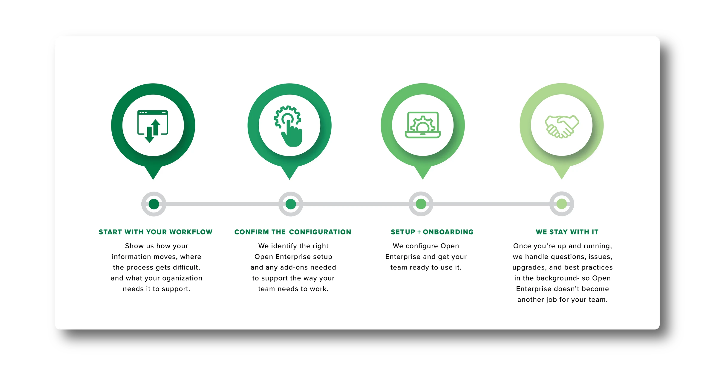
How it works
A clear path from workflow
problem to managed capability.



When needs change
When your needs change,
Open Enterprise can too.
Core program
Always included
The core services above remain part of Open Enterprise, including hosting, configuration management, backup and recovery, break/fix, and ongoing technical management.
Standard add-ons
Add them as your needs change
Additional editor capacity, browser-based editing and custom web maps, departments or groups, defined data connections, priority support, and other standardized capabilities can be added when needed.
Need something more custom?
We can help
Just tell us what you're trying to accomplish. We'll help determine whether it fits within Open Enterprise or needs a separate GEOACE scope.

Who it's for
Where Open Enterprise fits, and where GEOACE picks up.
When Open Enterprise is a fit
- Field and office information still moves through fragmented or manual steps.
- Growth, a new project, contract, grant, or compliance need is pressuring an older process.
- GIS responsibility sits with limited staff capacity.
- You need reliable capability without building a full GIS function internally.
When Open Enterprise isn't, but GEOACE still may be
- You already have a mature, fully staffed GIS program.
- Your primary need is advanced governance, enterprise strategy, or organizational study work.
- You need substantial custom development or a complex migration rather than a repeatable managed workflow.
- Your core need is advanced presentation or analytics functionality beyond the standard Open Enterprise model.
Already use other systems? That doesn't automatically disqualify you.
Open Enterprise can work alongside existing systems where the workflow and connection are supported. Defined, repeatable connections can be handled as add-ons; more complex integration requirements may need separate technical scoping.
Transparent pricing
See the cost before you schedule a conversation.
Open Enterprise starts with one core managed relationship, then adds standardized capabilities only when your organization needs them. No application. No self-serve signup. Get your number below, then decide if a conversation makes sense.
What would your program cost?
Answer a few questions about how your team works. The number updates as you go. Nothing is submitted until you're ready to talk.
What happens next? If the pricing makes sense, let's have a quick conversation and explore the fit. We'll confirm the configuration, add-ons, and terms, then schedule the setup.
Why GEOACE
The experience of GEOACE, built into Open Enterprise.
Our GIS experience and credentials are part of the program, along with a team that understands how it is built and can help it evolve as your needs change.
Open Enterprise is a GEOACE program, not a separate company or a handoff to a third-party implementation team.
GEOACE GIS work, in practice

Ongoing GIS support since 2021, from restoring a non-functional map suite in the first week to managing road, utility, and water department data across the City and Muskingum County.

GIS implementation and ongoing support for high-voltage transmission line projects, built on ArcGIS Online so Altitude Energy's own team can track project data independently.

A field-to-office data pipeline supporting reforestation on the Central Ohio Chapter's Poston Preserve, from sub-meter tree surveys in 2019 to roughly 2,500 trees planted in each of the past two years, with 3,000 to 10,000 projected for 2026.
FAQ
The questions we hear before someone calls.
What exactly is Open Enterprise?
Open Enterprise is a GEOACE-managed GIS program built around your field-to-office workflow. We configure it around the way your team works, help your team get up and running, and manage the program over time.
Do we need someone on staff who already knows GIS?
No. You don't need someone on staff who already knows GIS, though it's completely fine if you do. The exact user roles and onboarding needs are confirmed during the fit conversation.
What is included in the base monthly price?
The base monthly price covers the core Open Enterprise program, including setup and configuration, core onboarding, hosting and storage, applicable platform and license management, configuration management, backup and recovery, break/fix, and ongoing technical management.
Standard add-ons such as additional editor capacity, browser-based editing and custom web maps, departments or groups, data connections, and priority support are priced separately when needed. Substantial custom development, complex migrations, or work outside the Open Enterprise model is scoped separately.
What counts as a "department"?
A separate project environment with its own permission structure and data schema. Think Parks and Public Works needing to keep their data and access independent of each other, not just two people on the same team. The base subscription includes one; additional departments each come with 3 more floating editor seats included.
What's the difference between an editor seat and a viewer?
Editor seats are floating and shared. Anyone on your team can check one out to collect or edit data, and you're billed for how many people need to do that at once, not for every named user. Viewers are unlimited and free on every tier, whether that's five board members or the general public looking at a shared map.
Can Open Enterprise work with systems we already use?
Often, yes. Defined, repeatable connections can be added to Open Enterprise, while more complex integration requirements may need separate technical scoping. In some cases, like ArcGIS REST, the service can be connected directly at the source instead of copying data into Open Enterprise. When that's possible, there's no ongoing maintenance and no cost to integrate.
We're constantly evaluating new integrations and this list isn't exhaustive. If you don't see what you need, let us know and we'll research what it would take to add it at no charge.
What happens if we need more than 2 data connections per department?
That level of connectivity is scoped as its own project rather than an add-on, since it usually means more custom data handling than a flat per-connection rate accounts for. Add another department if that fits how your data is actually organized, or talk to us and we'll scope it directly.
What if we need to give our data to a client or vendor?
We classify this as a "simple request," which is included in your core program tier. These are generally infrequent (less than once a month, though circumstances vary), and we're happy to accommodate them.
Your core program tier already includes:
- Initial setup + configuration
- Core onboarding
- Hosting + storage
- Platform + license management
- Configuration management
- Backup + recovery
- Break/fix coverage
- Ongoing technical management
Does a web map only come with the web package?
No. A view-only web map is included in the baseline package, delivered in the browser through Mergin Maps, the same field collection and syncing tool your team already uses. The web package add-on is what you'd need for a public-facing map or for sharing data with outside systems, not just for viewing your own data online.
Is there a setup fee for the base subscription?
No. The monthly price covers hosting, configuration, and onboarding. The only standard one-time fees are tied to specific data connections (shown per-connection in the calculator above) and are billed once, at project start. Substantial custom workflow configuration is scoped separately.
What if we need something custom later?
Standard add-ons can be added within Open Enterprise as your needs change. More substantial custom development, complex migrations, or other specialized work may require a separate scope, but that doesn't necessarily mean it sits outside Open Enterprise permanently. Once that work is complete, the new functionality or data may be able to integrate back into the program.
If we have our own GIS person on staff already, can they extend what GEOACE has built with us?
Yes, particularly for Mergin Maps. That said, they take on responsibility for break/fix on anything they extend going forward, unless it's explicitly signed off by GEOACE. For customers with the web package, web applications are also extendable, but the updated map needs to be sent to GEOACE to vet and subsequently upload to the web portal.
Is this estimate a final quote?
It's a planning number based on what you've told the calculator, not a binding quote. We'll confirm final pricing on a call once we understand your workflow in more detail.